


PRECINCT TWO RIDGE, Jefferson County, Ohio
About
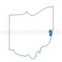
Outline

Summary
| Unique Area Identifier | 648082 |
| Name | PRECINCT TWO RIDGE |
| County | Jefferson County |
| State | Ohio |
| Area (square miles) | 5.06 |
| Land Area (square miles) | 5.06 |
| Water Area (square miles) | 0.00 |
| % of Land Area | 100.00 |
| % of Water Area | 0.00 |
| Latitude of the Internal Point | 40.39550610 |
| Longtitude of the Internal Point | -80.72344700 |
Maps


Graphs
Select a template below for downloading or customizing gragh for PRECINCT TWO RIDGE, Jefferson County, Ohio


Neighbors
Neighoring Voting District (by Name) Neighboring Voting District on the Map
- PRECINCT BELVEDERE, Jefferson County, OH
- PRECINCT MT TABOR, Jefferson County, OH
- PRECINCT PLEASANT HILL 1, Jefferson County, OH
- PRECINCT SHELLEY, Jefferson County, OH
- PRECINCT STEUBENVILLE 6-2, Jefferson County, OH
- PRECINCT WEST PARK, Jefferson County, OH
- PRECINCT WINTERSVILLE A, Jefferson County, OH
- PRECINCT WINTERSVILLE D, Jefferson County, OH
Top 10 Neighboring County Subdivision (by Population) Neighboring County Subdivision on the Map
- Steubenville city, Jefferson County, OH (18,659)
- Island Creek township, Jefferson County, OH (10,546)
- Cross Creek township, Jefferson County, OH (8,348)
- Salem township, Jefferson County, OH (3,148)
- Wayne township, Jefferson County, OH (2,232)
Top 10 Neighboring Place (by Population) Neighboring Place on the Map
Top 10 Neighboring Unified School District (by Population) Neighboring Unified School District on the Map
Top 10 Neighboring State Legislative District Lower Chamber (by Population) Neighboring State Legislative District Lower Chamber on the Map
Top 10 Neighboring State Legislative District Upper Chamber (by Population) Neighboring State Legislative District Upper Chamber on the Map
Top 10 Neighboring 111th Congressional District (by Population) Neighboring 111th Congressional District on the Map
Top 10 Neighboring Census Tract (by Population) Neighboring Census Tract on the Map
- Census Tract 115, Jefferson County, OH (5,305)
- Census Tract 12, Jefferson County, OH (5,287)
- Census Tract 117, Jefferson County, OH (4,426)
- Census Tract 114.02, Jefferson County, OH (4,046)